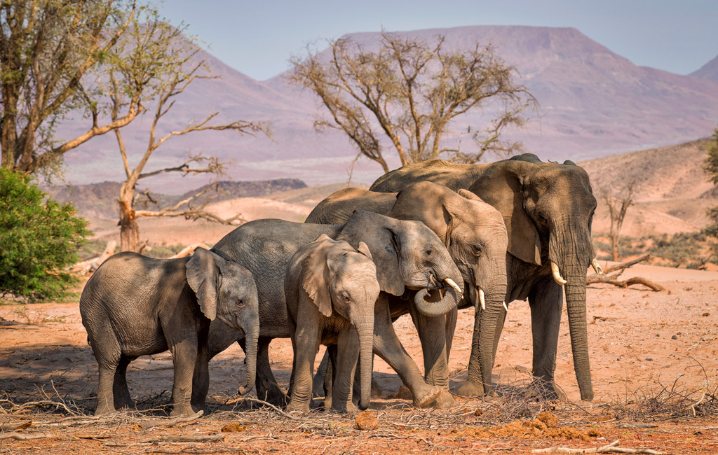
Habitat connectivity is one of the most critical concepts in the conservation of iconic animal species – and one of the most challenging to achieve as the human population expands. New research based on nearly three decades of elephant data explores how elephants move across the landscapes of southern Africa through protected areas and beyond.
Many of the world’s remaining large mammal species survive in small, fragmented populations isolated in protected areas and surrounded by a sea of human development. Around 80% of Africa’s savannah elephants occur in Southern Africa, predominantly in protected areas in the form of national parks and reserves. Though the space available to them is significant (nearly a million km2), connectivity between populations is a vital consideration for future population viability and persistence. Confining elephants to designated protected areas without the possibility of movement risks severe demographic challenges and the loss of genetic diversity.
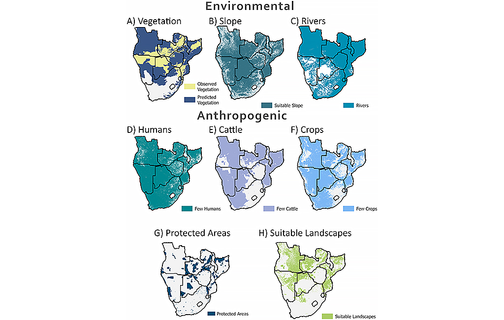
To investigate how elephants utilise habitats across southern Africa, scientists examined over a million telemetry observations from 254 collared elephants spanning nearly three decades. Their goal was to determine areas of feasible connectivity between populations and, conversely, where movement between populations is no longer possible. To do this, they set about determining “where elephants want to go” and exploring how human actions restrict this movement. They then investigated how these factors vary across different landscapes through a series of case studies of distinct habitats in southern Africa. Finally, the authors describe the specific routes of connectivity that remain potentially accessible to elephant populations.
“Where do elephants want to go?”
Of the 252 different vegetation zones mapped by the Southern Africa Regional Science Initiative Project in Southern Africa, the telemetry data revealed that the elephants were utilising 83 of these zones. The authors then investigated the tree species occurring in these regions and predicted that a further 76 vegetation zones might be suitable for elephants.
Previous research has shown that elephants prefer to avoid steep slopes, as confirmed by the telemetry data in the new study. 95.8% of the recorded data points occurred on predominantly flat terrain. Consequently, hilly terrain acts as a barrier to elephant movement. Unsurprisingly, the presence of larger river systems also influenced elephant distribution, with 94.7% of elephant data points lying within 10km of a seventh-order river or higher. (Streams and rivers can be classified as numbered “orders”, with a first-order stream being the smallest and the Amazon River considered a 12th-order stream.)
“How human actions restrict elephant movements”
As expected, the researchers found a strong relationship between areas with low agricultural potential, human densities, and elephant movement. This was the case even outside protected areas. Fences almost invariably acted as a restriction to elephant movement but for the few instances where gaps allowed for their passage. Unfenced areas allowed elephants to move freely, including beyond the boundaries of protected areas.

Case studies on the movements of elephants
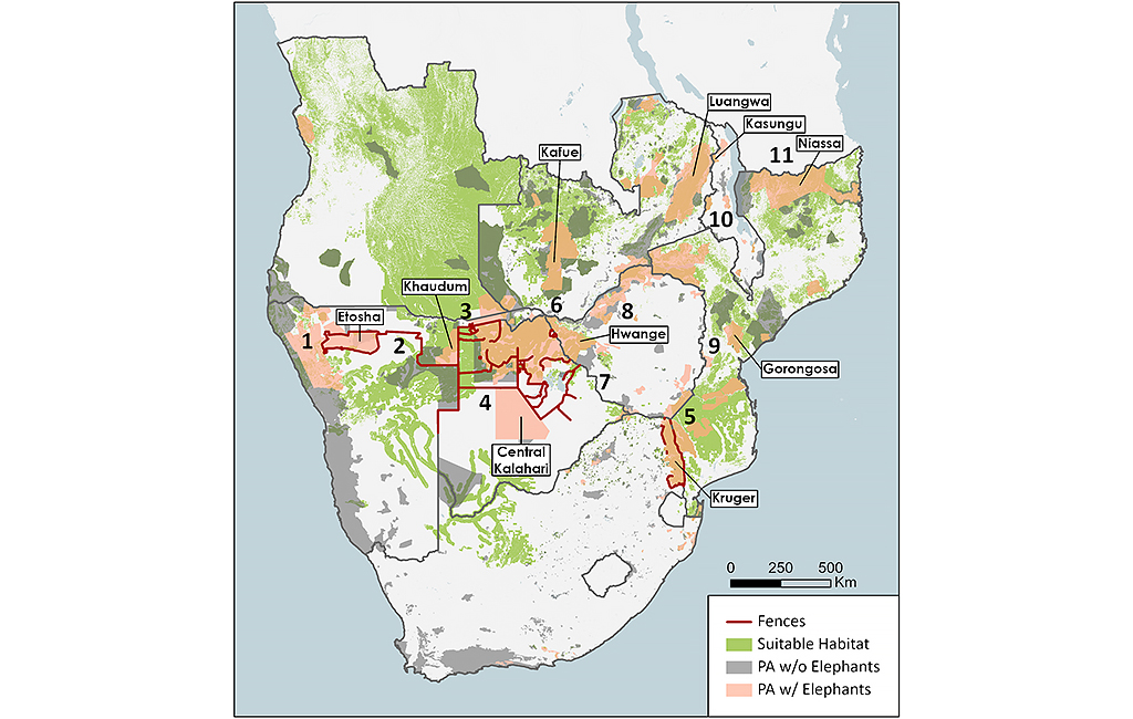
Having identified the factors (natural and anthropogenic) that influence elephant movement, the authors then used regional case studies to contextualise this information. To do so, they assigned the elephant movement data into eight “clusters” of protected areas:
- Etosha (Namibia)
- Chobe (northern Botswana, Zambezi region of Namibia [formerly called the Caprivi Strip] and parts of north-west Zimbabwe)
- Kafue (Zambia)
- Limpopo, which includes Kruger National Park (South Africa, Zimbabwe, and Mozambique)
- Luangwa (Zambia and Malawi)
- Maputo (southern Mozambique and South Africa)
- Niassa (Mozambique)
- Zambezi (Zambia and Zimbabwe)
For each cluster, they systematically examined where the elephants would want to move to, where they dispersed in reality and what factors influenced this movement. For example, fences and water availability created significant barriers to elephant dispersal in Namibia, South Africa, and Botswana. In Etosha National Park in Namibia, the elephants were prevented from dispersing east to the wetter regions of the country by fences surrounding the park. However, gaps in the southwestern fence line allowed them to move west in the arid communal conservancies. Here, the elephants were restricted to dry riverbeds where they could dig for water, but human-elephant conflict has increased, particularly due to competition over water resources. Likewise, the international border fence between Namibia and Botswana acts as a barrier to elephant movement, even within the Kavango-Zambezi Transfrontier Conservation Area.
Through these case studies, the researchers also identified areas of feasible movement, such as between populations in the Greater Limpopo Transfrontier Conservation Area (including the Kruger National Park) and Banhine and Zinave National Parks. They also acknowledged that connectivity is no longer achievable in some areas, as in Malawi (one of the most densely populated African countries) and between the southern and northern sections of Mozambique. In these regions, the growth of the human population and the increased need for agricultural land make the creation of corridors impossible.
Mapping elephant connections
This painstaking process allowed the researchers to create a series of maps to illustrate the interplay of various factors. “[These] maps help us to consider the prospects of how we can improve the connections between the different protected areas that harbour elephants in Southern Africa,” said one of the lead authors, Professor Rudi Van Aarde.
From fences to human-wildlife conflict, the challenges to elephant habitat connectivity are substantial, but many of these areas represent the last opportunities to create such linkages between protected areas. The authors are particularly critical of the impact of fences on elephant populations. They argue that while there are unequivocally situations where fencing is appropriate, it is essential to balance the need for fences against connectivity.
They also acknowledge that the potential to connect elephant populations is most dependent on socio-political will, and it will also inevitably require local community members to coexist with elephants. Yet, for all the effort needed, the researchers conclude that, “protecting the connections identified here for dispersal may represent some of our best chances at a sustainable future for elephants.”
Resources
View the original paper here: Ryan M Huang et al. (2022) “Mapping Potential Connections between Southern Africa’s Elephant Populations,” PLOS ONE, 17(10)
Read more about how Chobe elephants have learnt how to change their activity patterns to reduce risk of human encounters.
Read more about the importance of corridors to elephant movement here.
To comment on this story: Login (or sign up) to our app here - it's a troll-free safe place 🙂.![]()